This is the Saint Louis Science Center’s DAY SKY UPDATE for the Month of June2025.
Information updated monthly or as needed.
Times given as local St. Louis time which is Central Daylight Time (CDT). For definitions of terminology used in the night sky update, click the highlighted text. If relying on times posted in Universal Time (UT), St. Louis is -5 hours when CDT. Additionally, times will be posted in a 24-hour format.
Join us for our next solar telescope viewing, Sunday, June 6, 2025, held in association with the St. Louis Astronomical Society. For details, see the information at the bottom of this page or visit
Daytime Astronomy Primer
For most, astronomy is a hobby that is left to the darkness of night. While most astronomical objects are only visible at night, the day sky can offer a careful observer several astronomical targets along with a multitude of atmospheric phenomena to enjoy. When posted, the DAY SKY UPDATE will explore these possibilities which may include a highlight of the month, cloud observing, sun rise/set times, daytime Moon information, daytime planets and other topics. As always, when viewing during daytime, you must use caution as the Sun is always near.
Aside from solar filters, there are other safety steps that you should consider. Sunscreen, hats and sunglasses are always advisable. Visible light is how we observe the world around us, however, there is light we cannot see. Ultraviolet (UV) and infrared (IR) light are great examples of this. While both are an issue if you are using an optical system, UV light is an issue through exposure. This can be mitigated by using sunscreen, sunglasses and limiting exposed skin. While sunglasses are not safe instruments to view the Sun with, they do protect your eyes from exposure to ultraviolet light that we are susceptible to during the day. If you would like to learn more about UV and its dangers use the buttons below.
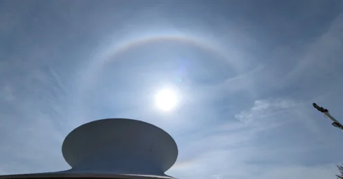
Cloud of the Month
June is the start of Hurricane season. It’s crucial to understand the formation of hurricanes, their life cycle, and their tracks, so that we know how to be prepared and stay safe through these intense storms. Even though St Louis isn’t in the direct path of hurricanes, it’s important to remember that these storm systems can live long and evolve. Those who live inland can still experience significant impacts from the remnants of these tropical storms.
A hurricane (also known as a tropical cyclone) is an intense storm system originating in the tropics, with sustained winds of at least 64 knots (74 mph). They are comprised of very intense convective clouds that can grow to over 50,000 ft. The name hurricane is used to describe tropical cyclones that occur over the Atlantic and eastern Pacific Oceans. They are called typhoons when the occur over the western Pacific and are called cyclones when they occur over the Indian Ocean.
Hurricanes only form in the tropics, the region being 23.5° north and 23.5° south of the equator. This is where wind tends to be light, humidity is high, and where surface water tends to stay above 80 degrees Fahrenheit. All these conditions dominate over the tropical and subtropical North Atlantic and Northeast Pacific oceans during the summer and early fall. They reach peak sea surface temperatures in late August and early September. The official hurricane season is from June 1st to November 30th, but of course tropical storms and hurricanes have formed outside of these dates.
Hurricane structure
Eye – This is the clear center of the storm. Within the eye, it is fairly calm, being mostly cloud free, and winds that usually don’t exceed 15 mph. The eye itself ranges from 20-40 miles across and will start to form when the storms winds exceed 74 mph. This is also where the surface air pressure is at its lowest.
Eyewall – Surrounding the eye is a ring of intense thunderstorms that usually produce the strongest winds and heaviest rain fall and can extend upward to almost 9 miles above the ocean surface. Air in the convective clouds rise upward and outward forming a funnel, creating violently rotating storms around the eye. Outside the eyewall, winds are still moderately strong, but precipitation can be light.
Rainband – These are bands of clouds and thunderstorms that extend away from the eye wall in a spiral fashion. These rain bands can produce heavy bursts of rain and wind, as well as tornadoes and can extend hundreds of miles from the center of the storm. Hurricanes are also not as symmetrical as they seem, most of the rain will fall on the east side of the storm, and there can also be gaps where there is no rain.
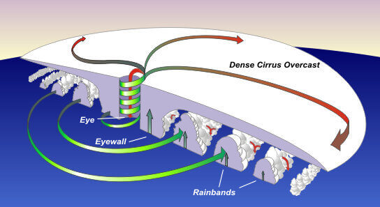
Image showing a cross section of a hurricane. Image credit: NOAA
Hurricane formation and evolution
Before a hurricane exists, a cluster of thunderstorms must develop first. Low level convergence is required to lift air to trigger these initial thunderstorms. In the northern hemisphere, converging air spins counterclockwise around an area of surface low pressure. It’s important to note that this type of rotation does not occur on the equator because of the Coriolis force.
One of the main ways that convergence develops is from the Intertropical Convergence Zone (ITCZ), which is a boundary separating the northeast trade winds of the Northern Hemisphere from the southeast trade winds of the Southern Hampshire. A tropical wave will form along the ITCZ, causing a low to develop and convention will become organized.
Hurricanes require certain environmental conditions to form, even after clusters of thunderstorms have formed.
- Sea surface temperature must exceed 80°F. The energy from a hurricane comes from the heat and moisture supplied by the ocean. The higher the temperature of the uppermost layer of the ocean, the stronger the convective storms will be. Once sea surface temperatures drop below 80°F, the ocean cannot supply enough moisture and heat to sustain thunderstorm formation.
- The surface layer of warm ocean water must be significantly deep, typically around 200 ft or more. A deep layer of warm water is required for hurricane development because a hurricane will mix up and stir the ocean water. This stirring leads to upwelling of water in the eye and eyewall, and if that warm layer is shallow, the cold water will rise to the surface killing its energy source. Hence hurricane season peaking in late summer when waters and temperatures are at their warmest.
- There needs to be weak vertical wind shear, meaning upper-level winds must not change drastically with height. Strong vertical wind shear will disrupt the organized pattern of convection and disperse moisture and heat.
- The middle troposphere must contain sufficient moisture. If the middle troposphere is too dry, mixing of the dry air and rising thunderstorm will weaken the storms updraft, reduce latent heating, and create evaporatively cooled downdrafts. All of which suppresses the storms development and organization. Saharan air layers (dry air that gets lofted into the middle troposphere from the Sahara Desert) can be a source to suppress hurricane formation.
- Location of hurricane formation must be at least 5° north or south of the equator because of the Coriolis force. The Coriolis force results from Earths spherical shape and rotation. This keeps air from moving in a straight line, making air spin to the right in the Northern Hemisphere and to the left in the Southern Hampshire. The Coriolis force is the strongest at the poles, and zero at the equator. So even though thunderstorms can form at the equator, they cannot develop the needed circulation to become hurricanes.
Tropical cyclones are classified by their maximum sustained wind speeds. In the United States, the maximum sustained wind is based on 1-minute averages, while outside of the US it’s based on 10-minute averages. But of course, these storms have to start somewhere.
A tropical disturbance is a tropical weather system of organized thunderstorms. These storms tend to be around 150 to 350 miles in diameter and maintains its structure for more than 24 hours. It’s important to note that tropical disturbances will not have a closed circulation.
Once a cluster of thunderstorms experiences a pressure drop and forms a closed wind circulation (not exceeding 39 mph), it is classified as a tropical depression. It will then be given a number, the first of the year called tropical depression #1 and so on.
Once winds exceed 39 mph, the system becomes a tropical storm. This is also when the storm gets its name, and it will keep its name for the rest of its life cycle. The name list is alphabetical (but will skip letters Q, U, X, Y, Z), will alternate male and female names, and uses names from English, Spanish, and French languages. If a season goes past the assigned list, the storms will be given names from the Greek alphabet. Names of particularly devastating hurricanes will get retired like Katrina (2005), Sandy (2012), and Harvey (2017) for example. The name lists are also on a 6-year cycle. So, the names being used in 2025 are the same ones used back in 2019.
Once winds reach 75 mph, the storm has officially become a hurricane and is then classified by the Saffir-Simpson intensity scale. The scale used to be based on wind speed, central pressure, and storm surge, but was revised in 2010 to be based solely on wind speed. Cat 1 having winds between 74 and 95 mph, Cat 2 having winds between 96 and 110 mph, Cat 3 being between 111mph and 130 mph, Cat 4 being between 131 mph and 155 mph, and Cat 5 having winds speeds higher than 155 mph.
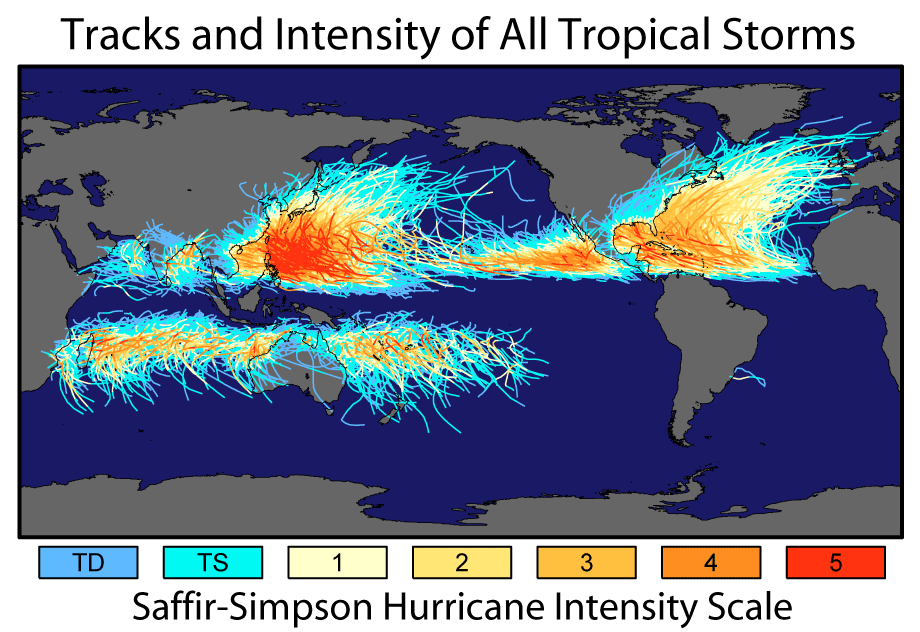
Image showing 150 years of storm tracks and storm intensity. Image credit: NASA Earth Observatory
When hurricanes make landfall, they start to lose their strength because it loses its primary source of energy. The lack of warm water reduces moisture and the increased friction from the land will cause the storm to dissipate. However, they can still cause significant damage and be very dangerous. Storm surge is one of the greatest concerns to those in coastal areas because of the intense amount of flooding. Because St Louis is far from coastlines, it’s not really something to worry about, but inland flooding, high winds, and tornadoes are something to look for.
Hurricanes will produce very heavy rains as it moves over land, especially when the storm slows down significantly, having rains last multiple days. This will cause incredible floods along rivers and streams. The continuous storm system will still have very high winds which can cause significant damage to an area as well. Tornadoes are also not rare when the system moves over land. These tornadoes tend to be in the EF0 and EF2 range but can become very dangerous in many cases because they are rain wrapped, making them hard to see. It’s important to remember that those who are inland and not in the direct path of a hurricane can still experience the impact after it has made landfall. Like always, make sure to stay weather aware and especially during hurricane season. Make sure to visit the National Hurricane Center for the latest updates.
The Sun and the Moon
Sun Information
The month of June sees the Sun reach its northern standstill on June 20, 2025. If you track the position of sunrise or sunset this month you will find these positions are shifting to the north until June 20th after which they slowly start to head south after the June solstice. Maximum altitude also changes each day. From June 1, 2025, to June 20, 2025, the Sun’s maximum altitude will shift from 73.5° to 74.8°. By June 30, 2025, the Sun’s maximum altitude will be 74.5°.
The next major position of the Sun occurs on June 20, 2025, as the Sun reaches the June Solstice. For us in the northern hemisphere, this is the Summer Solstice which signals the start of summer. The world around us will continue to bloom. Severe weather will likely continue this month. Lighting bugs/Fireflies should start appearing soon.
Sunrise and Sunset Times for St. Louis Missouri
The sunrise and sunset times below were calculated by the Earth Systems Research Laboratories for NOAA. These times are calculated using equations for Jean Meeus’s Astronomical Algorithms. The atmosphere complicates these calculations due to the refraction of sunlight as it passes through the atmosphere. For the times listed below, the amount of atmospheric refraction is assumed to be 0.833°. Variations in the atmosphere can change the amount of refraction so the times posted are accurate to within a minute for latitudes between +/- 72°. You can learn more about these calculations and where to generate times for areas outside of St. Louis, Missouri by using the buttons below
Moon (daytime views)
The Moon is one of the best daytime targets. Throughout most of the synodic month, the Moon can be viewed during the day. There are, however, ideal phases during which the Moon is much easier to find and see. There are only two phases of the Moon during which it is not visible in daytime; these are new moon and full moon. During new moon, the Moon is between Earth and the Sun. The side facing us is not reflecting sunlight and will not be visible. The only time we can see the Moon during new moon is when we see its silhouette during a solar eclipse.
During full moon, daytime views are not possible because the Moon is appearing near the anti-solar point in the sky. Because of this position, the Moon rises while the Sun is setting. The closer the moon is to one of these two phases, the more difficult it is to find it in daytime.
The ideal time to look for the Moon during the day is when the Moon is near a quarter phase. During a quarter phase, the contrast between the Moon and the sky will be good making it easier to find. If the Moon is near first quarter, you should look for it in the afternoon. If it is near last quarter, look for it in the morning. The table below will list the main phases of the Moon for the current lunation.
Solar Sunday is now held every Sunday through Labor Day from 11:00 a.m. until 3:00 p.m. (Weather Dependent)
On Sundays through Labor Day, the St. Louis Astronomical Society and the Saint Louis Science Center will set up a number of safe solar telescopes outdoors and be on-hand to answer your questions. Telescope viewing begins at 11:00 a.m.
The St. Louis Astronomical Society helps host the monthly Star Parties at the Saint Louis Science Center. In addition to our daytime viewings, they also help facilitate our nighttime Public Telescope Viewing. These nighttime viewing sessions occur on the 1st Friday each month. Visit SLAS’s website linked above to learn about other telescope events SLAS hosts around the St. Louis area.
The Day Sky Update is compiled by McDonnell Planetarium staff.